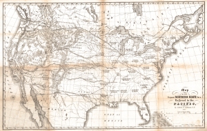
The Connecticut Historical Society has just completed a major map project, Maps and Charts: Finding Your Place in Connecticut History, with funding from Connecticut Humanities and the William and Alice Mortensen Foundation. Eight hundred maps from the CHS collection may now be viewed in the CHS online catalog. This 1853 map showing proposed routes for a transcontinental railroad is one of my favorites. It was drawn by Edwin F. Johnson, a civil engineer from Middletown, Connecticut, and printed by E.B. & E.C. Kellogg in Hartford. Johnson was born in Vermont in 1803 and served as surveyor general of Vermont, before moving to Middletown, where he established the first department of civil engineering in the country at the Military College that was the precursor to Wesleyan University. Johnson was not just a teacher, however; he was a practical engineer who worked on many early New England railroads, including the New York & Boston Air Line Railroad. As early as 1840, he was advocating a railroad to the West, crossing the Mississippi River at Rock Island, Illinois. In 1853, he published a pamphlet recommending the route later developed by the Northern Pacific Railroad, of which he eventually became chief engineer. This map accompanied the pamphlet and illustrated the proposed route. The first continental railroad, the Union Pacific, was completed in 1869. The Northern Pacific was still under construction when Johnson died in 1872
inside the CHS
